
Mapa topográfico Corregidor Island
Mapa interactivo
Haga clic en el mapa para ver la altitud.
Acerca de este mapa
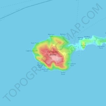
Nombre: Mapa topográfico Corregidor Island, altitud, relieve.
Altitud media: 11 m
Altitud mínima: -1 m
Altitud máxima: 180 m
The tadpole-shaped island, with its tail running eastward, is about 6.5 km (4.0 mi) long, about 2.0 km (1.2 mi) wide at its widest with a total land area of about 900 hectares (2,200 acres). The highest elevation is at 180 m (590 ft) on the Topside.[5] The island is divided into four sections:
Otros mapas topográficos
Haga clic en un mapa para ver su topografía, su altitud y su relieve.
Cavite City
Philippines > Cavite > Cavite City
Cavite City, Cavite, Calabarzon, 4100, Philippines
Altitud media: 13 m