
Mapa topográfico Eagle County
Mapa interactivo
Haga clic en el mapa para ver la altitud.
Acerca de este mapa
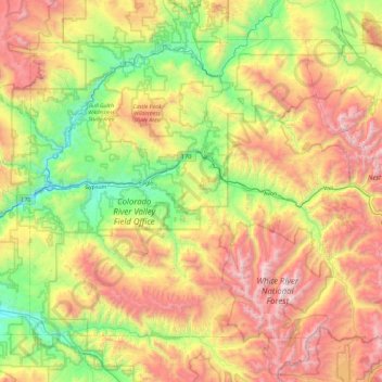
Nombre: Mapa topográfico Eagle County, altitud, relieve.
Lugar: Eagle County, Colorado, United States of America (39.34949 -107.11374 39.92530 -106.17557)
Altitud media: 2.769 m
Altitud mínima: 1.871 m
Altitud máxima: 4.196 m
The highest elevation in the county is the Mount of the Holy Cross which rises to 14,011 feet (4,271 m) above sea level. The lowest elevation is on the Colorado River at 6,128 feet (1,868 m).
Otros mapas topográficos
Haga clic en un mapa para ver su topografía, su altitud y su relieve.
Mount Wilson
United States of America > Colorado
Mount Wilson, Dolores County, Colorado, United States of America
Altitud media: 3.891 m
Denver County
United States of America > Colorado
Denver County, Colorado, United States of America
Altitud media: 1.673 m