
Haz una donación
Mapa topográfico College Park
Haga clic en el mapa para ver la altitud.
Haz una donación
College Park
College Park features a relatively flat terrain typical of the Atlantic Coastal Plain, with an average elevation of around 100 feet above sea level. The landscape is characterized by gently rolling hills, particularly in the northern and western parts, while lower-lying areas can be found near the various small streams and lakes, such as Lake Artemesia. The area is also notable for its proximity to the Anacostia River watershed, which contributes to the gentle gradients in the region. College Park is dotted with parks and green spaces that enhance the urban environment, providing residents with scenic views and recreational opportunities.
Haz una donación
Acerca de este mapa
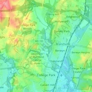
Nombre: Mapa topográfico College Park, altitud, relieve.
Altitud media: 38 m
Altitud mínima: 10 m
Altitud máxima: 100 m
Haz una donación
Otros mapas topográficos
Haga clic en un mapa para ver su topografía, su altitud y su relieve.
Haz una donación
Haz una donación
Haz una donación
Haz una donación
Mount Rainier Neighborhood Park
United States > Maryland > Prince George's County > Mount Rainier
Altitud media: 21 m
Farmington Road Estates
United States > Maryland > Prince George's County > Farmington Road Estates
Altitud media: 47 m
Haz una donación