
Gracias por apoyar a este sitio ❤️
Haz una donación
Haz una donación
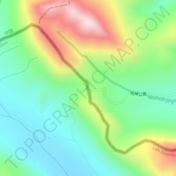
Mapa topográfico Karakoram Pass
Haga clic en el mapa para ver la altitud.
Gracias por apoyar a este sitio ❤️
Haz una donación
Haz una donación
Karakoram Pass
Historically, the high altitude of the pass and the lack of fodder were responsible for the deaths of countless pack animals while the route was notorious for the trail of bones strewn along the way. There is an almost total absence of vegetation on the approaches to the pass.
Gracias por apoyar a este sitio ❤️
Haz una donación
Haz una donación
Acerca de este mapa
Nombre: Mapa topográfico Karakoram Pass, altitud, relieve.
Lugar: Karakoram Pass, Nubra, Leh District, Ladakh, India (35.51341 77.82265 35.51351 77.82275)
Altitud media: 5.521 m
Altitud mínima: 5.300 m
Altitud máxima: 5.931 m
Gracias por apoyar a este sitio ❤️
Haz una donación
Haz una donación