
Mapa topográfico Montpellier
Mapa interactivo
Haga clic en el mapa para ver la altitud.
Acerca de este mapa
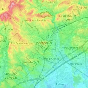
Nombre: Mapa topográfico Montpellier, altitud, relieve.
Lugar: Montpellier, Hérault, Occitania, Metropolitan France, France (43.56671 3.80706 43.65336 3.94132)
Altitud media: 41 m
Altitud mínima: -1 m
Altitud máxima: 129 m
Montpellier's highest point is the Place du Peyrou, at an altitude of 57 m (187 ft). The city is built on two hills, Montpellier and Montpelliéret, thus some of its streets have great differences of altitude. Some of its streets are also very narrow and old, which gives it a more intimate feel.
Otros mapas topográficos
Haga clic en un mapa para ver su topografía, su altitud y su relieve.
La Roueyre
France > Occitania > Hérault > Mons
La Roueyre, Mons, Béziers, Hérault, Occitania, Metropolitan France, 34390, France
Altitud media: 485 m
Cazelles
France > Occitania > Hérault > Aigues-Vives
Cazelles, Aigues-Vives, Béziers, Hérault, Occitania, Metropolitan France, 34210, France
Altitud media: 173 m
La Chevalière
France > Occitania > Hérault > Béziers
La Chevalière, Béziers, Hérault, Occitania, Metropolitan France, 34500, France
Altitud media: 49 m