
Gracias por apoyar a este sitio ❤️
Haz una donación
Haz una donación
Mapa topográfico Cheatham Dam
Haga clic en el mapa para ver la altitud.
Gracias por apoyar a este sitio ❤️
Haz una donación
Haz una donación
Acerca de este mapa
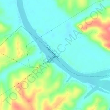
Nombre: Mapa topográfico Cheatham Dam, altitud, relieve.
Altitud media: 135 m
Altitud mínima: 111 m
Altitud máxima: 191 m
Gracias por apoyar a este sitio ❤️
Haz una donación
Haz una donación
Otros mapas topográficos
Haga clic en un mapa para ver su topografía, su altitud y su relieve.
Cheatham State Wildlife Management Area
United States > Tennessee > Cheatham County
Altitud media: 205 m
Gracias por apoyar a este sitio ❤️
Haz una donación
Haz una donación