
Mapa topográfico Hillcrest
Mapa interactivo
Haga clic en el mapa para ver la altitud.
Acerca de este mapa
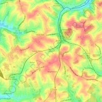
Nombre: Mapa topográfico Hillcrest, altitud, relieve.
Altitud media: 357 m
Altitud mínima: 302 m
Altitud máxima: 397 m
Otros mapas topográficos
Haga clic en un mapa para ver su topografía, su altitud y su relieve.
Bethel
United States > Pennsylvania > Allegheny County > Bethel Park
Bethel, Bethel Park, Allegheny County, Pennsylvania, 15102, United States
Altitud media: 353 m