
Gracias por apoyar a este sitio ❤️
Haz una donación
Haz una donación
Mapa topográfico Chammünster
Haga clic en el mapa para ver la altitud.
Gracias por apoyar a este sitio ❤️
Haz una donación
Haz una donación
Acerca de este mapa
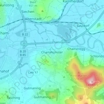
Nombre: Mapa topográfico Chammünster, altitud, relieve.
Lugar: Chammünster, Cham, Landkreis Cham, Bayern, 93413, Deutschland (49.19042 12.67515 49.23042 12.71515)
Altitud media: 399 m
Altitud mínima: 366 m
Altitud máxima: 592 m
Gracias por apoyar a este sitio ❤️
Haz una donación
Haz una donación
Otros mapas topográficos
Haga clic en un mapa para ver su topografía, su altitud y su relieve.