
Mapa topográfico Cleveland
Mapa interactivo
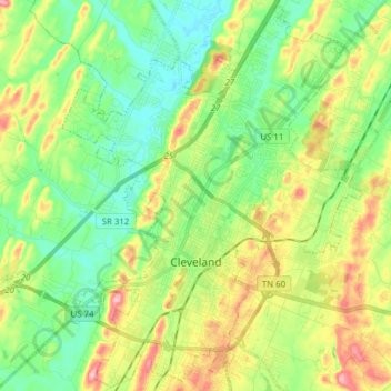
Haga clic en el mapa para ver la altitud.
Acerca de este mapa
Nombre: Mapa topográfico Cleveland, altitud, relieve.
Altitud media: 264 m
Altitud mínima: 212 m
Altitud máxima: 355 m
The area's terrain is made up of parallel ridges, including Candies Creek Ridge (also called Clingan Ridge), Mouse Creek/Lead Mine Ridge, and Blue Springs Ridge, which are extensions of the Appalachian Mountains (specifically part of the Ridge-and-Valley Appalachians) that run approximately north-northeast through the area. Mouse Creek and Blue Springs Ridge have significantly lower elevations within the city of Cleveland than elsewhere in Bradley County, which historically made the area easier to settle. Several streams run in the valleys between the ridges including Candies Creek, located west of Clingan Ridge, and South Mouse Creek, between Mouse Creek and Lead Mine Ridge. Elevations in the city range from just under 700 feet (210 m) to nearly 1,200 feet (370 m). The Tennessee Valley Divide, the boundary of the Tennessee Valley and Mobile River drainage basins, is located on the southern and eastern fringes of the city, and has prevented the city limits from expanding beyond this point in most locations.
Otros mapas topográficos
Haga clic en un mapa para ver su topografía, su altitud y su relieve.
Mount Harmony
United States > Tennessee > Bradley County
Mount Harmony, Bradley County, East Tennessee, Tennessee, 37310, United States
Altitud media: 235 m
Charleston
United States > Tennessee > Bradley County
Charleston, Bradley County, Tennessee, United States
Altitud media: 234 m