
Haz una donación
Mapa topográfico College Park
Haga clic en el mapa para ver la altitud.
Haz una donación
College Park
The Lakeland neighborhood was developed beginning in 1890 around the Baltimore and Ohio Railroad, whose Branchville and Calvert Road depots were located approximately one mile to the north and south, respectively. Lakeland was created by Edwin Newman, who improved the original 238 acres (0.96 km2) located to the west of the railroad. He also built a number of the original homes, a small town hall, and a general store. The area was originally envisioned as a resort-type community. However, due to the flood-prone, low-lying topography, the neighborhood became an area of African-American settlement. Around 1900, the Baltimore Gold Fish Company built five artificial lakes in the area to spawn goldfish and rarer species of fish. By 1903 Lakeland was an established African-American community with a school and two churches. Lakeland was central in a group of African American communities located along Route One through Prince Georges County. Lakeland High School opened in 1928 with funding from the Rosenwald Fund, the African American community and the county. Lakeland High served all African American students in the northern half of the county until 1950 when it was converted to a facility for lower grades. The community's first Rosenwald school was a new elementary which opened in 1925.
Haz una donación
Acerca de este mapa
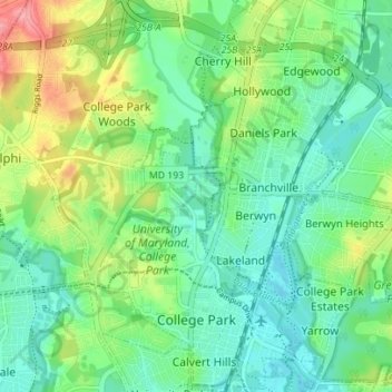
Nombre: Mapa topográfico College Park, altitud, relieve.
Altitud media: 38 m
Altitud mínima: 10 m
Altitud máxima: 100 m
Haz una donación
Otros mapas topográficos
Haga clic en un mapa para ver su topografía, su altitud y su relieve.
Haz una donación
Haz una donación
Haz una donación
Haz una donación
Mount Rainier Neighborhood Park
United States > Maryland > Prince George's County > Mount Rainier
Altitud media: 21 m
Farmington Road Estates
United States > Maryland > Prince George's County > Farmington Road Estates
Altitud media: 47 m
Haz una donación