
Mapa topográfico Braunfels
Mapa interactivo
Haga clic en el mapa para ver la altitud.
Acerca de este mapa
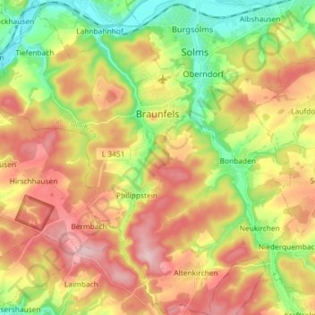
Nombre: Mapa topográfico Braunfels, altitud, relieve.
Lugar: Braunfels, Lahn-Dill-Kreis, Hesse, Germany (50.45627 8.31235 50.54840 8.45394)
Altitud media: 242 m
Altitud mínima: 133 m
Altitud máxima: 356 m
Otros mapas topográficos
Haga clic en un mapa para ver su topografía, su altitud y su relieve.
Aßlar
Germany > Hesse > Lahn-Dill-Kreis
Aßlar, Lahn-Dill-Kreis, Hesse, 35614, Germany
Altitud media: 280 m
Kraftsolms
Germany > Hesse > Lahn-Dill-Kreis
Kraftsolms, Waldsolms, Lahn-Dill-Kreis, Hesse, Germany
Altitud media: 280 m
Offdilln
Germany > Hesse > Lahn-Dill-Kreis > Haiger
Offdilln, Haiger, Lahn-Dill-Kreis, Hesse, Germany
Altitud media: 492 m
Haiger
Germany > Hesse > Lahn-Dill-Kreis
Haiger, Lahn-Dill-Kreis, Hesse, 35708, Germany
Altitud media: 409 m
Greifenstein
Germany > Hesse > Lahn-Dill-Kreis
Greifenstein, Lahn-Dill-Kreis, Hesse, 35753, Germany
Altitud media: 345 m