
Mapa topográfico City of Watertown
Mapa interactivo
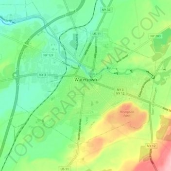
Haga clic en el mapa para ver la altitud.
Acerca de este mapa
Nombre: Mapa topográfico City of Watertown, altitud, relieve.
Altitud media: 150 m
Altitud mínima: 93 m
Altitud máxima: 261 m
Watertown is around 60 miles (97 kilometers) northwest of Syracuse, 20 miles (32 kilometers) south of the Thousand Islands and 328 miles (530 kilometers) northwest of New York City. According to the United States Census Bureau, the city has a total area of 9.3 square miles (24 km2), of which 9.0 square miles (23 km2) are land and 0.3 square miles (0.78 km2) (3.45 percent) is water. Before the area was settled, all the land was rough and forested. Elevation was also a problem. The Black River, flowing westward through the city toward Lake Ontario, is a world-renowned kayaking destination. Competition-level kayaking events, such as the Blackwater Challenge, have been held on the river.
Otros mapas topográficos
Haga clic en un mapa para ver su topografía, su altitud y su relieve.
Village of Adams
United States > New York > Jefferson County > Town of Adams
Village of Adams, Town of Adams, Jefferson County, New York, United States
Altitud media: 189 m
Village of Alexandria Bay
United States > New York > Jefferson County
Village of Alexandria Bay, Town of Alexandria, Jefferson County, New York, United States
Altitud media: 80 m
Thousand Islands
United States > New York > Jefferson County
Thousand Islands, Town of Orleans, Jefferson County, New York, 13640, United States
Altitud media: 111 m
Fort Drum
United States > New York > Jefferson County
Fort Drum, Town of Le Ray, Jefferson County, New York, United States
Altitud media: 174 m
Village of Black River
United States > New York > Jefferson County
Village of Black River, Town of Le Ray, Jefferson County, New York, United States
Altitud media: 193 m