
Haz una donación
Mapa topográfico Wasilla
Haga clic en el mapa para ver la altitud.
Haz una donación
Acerca de este mapa
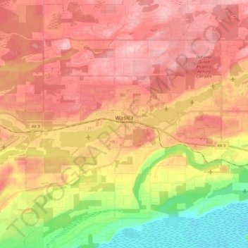
Nombre: Mapa topográfico Wasilla, altitud, relieve.
Lugar: Wasilla, Matanuska-Susitna Borough, Alaska, United States (61.55290 -149.56469 61.60653 -149.35364)
Altitud media: 98 m
Altitud mínima: 2 m
Altitud máxima: 166 m
Haz una donación
Otros mapas topográficos
Haga clic en un mapa para ver su topografía, su altitud y su relieve.
Willow
United States > Alaska > Matanuska-Susitna Borough
Willow has a subarctic climate with long and cold winters and mild summers. Whites Crossing is a weather station near Willow, situated at an elevation of 270 ft (82 m).
Altitud media: 69 m
Haz una donación
Haz una donación
Denali State Park
United States > Alaska > Matanuska-Susitna Borough
Denali State Park is in sight of Denali, the highest mountain peak in North America, with a summit elevation of 20,310 feet above sea level. Denali rises 18,000 feet from base to peak, making it the largest mountain situated entirely above sea level. To the east, the state park borders the Susitna River, which…
Altitud media: 702 m
Haz una donación