
Haz una donación
Mapa topográfico Trapper Creek
Haga clic en el mapa para ver la altitud.
Haz una donación
Trapper Creek
Trapper Creek is a community located in Matanuska-Susitna Borough at latitude 62.317 and longitude -150.231, with an elevation of 351 ft (107 m). It is at mile 114.5 on the Parks Highway, just south of Denali State Park. Trapper Creek is found at the intersection of Petersville Road and is spread out along the Parks Highway 15 miles (24 km) north of Talkeetna Junction. The Trapper Creek CDP extends west down the Petersville Road, which leads to mining, prospecting, and recreation country in the foothills of the Alaska Range.
Haz una donación
Acerca de este mapa
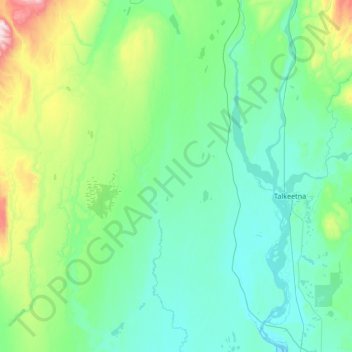
Nombre: Mapa topográfico Trapper Creek, altitud, relieve.
Altitud media: 235 m
Altitud mínima: 76 m
Altitud máxima: 1.080 m
Haz una donación
Otros mapas topográficos
Haga clic en un mapa para ver su topografía, su altitud y su relieve.