Geolocalizar

Mapa topográfico Dhalai

Haga clic en el mapa para ver la altitud.

Dhalai

The climate in Setrai, which is about 40 km from Ambassa, displays characteristics that are typical of the hilly and mountainous region. The change in the topographical features, heavy rainfall and altitude of the region causes a change in the climatic conditions in Setrai. The climate and other factors of the terrain and the soil are suitable conditions for horticulture.

Wikipedia (CC-BY-SA 3.0)

Acerca de este mapa

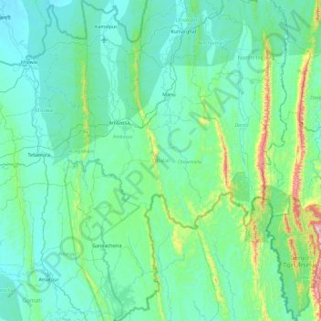
Nombre: Mapa topográfico Dhalai, altitud, relieve.

Lugar: Dhalai, Tripura, India (23.40625 91.74773 24.24118 92.17587)

Altitud media: 138 m

Altitud mínima: 15 m

Altitud máxima: 1.066 m

Otros mapas topográficos

Haga clic en un mapa para ver su topografía, su altitud y su relieve.

Kadamtala

India > Tripura > Dharmanagar

Altitud media: 27 m

Agartala

India > Tripura > Mohanpur

Altitud media: 23 m

Kakraban

India > Tripura > Kakraban

Altitud media: 21 m

Belonia

India > Tripura > Rajnagar

Altitud media: 20 m

Udaipur

India > Tripura > Matarbari

Udaipur is located at 23°32′N 91°29′E / 23.53°N 91.48°E / 23.53; 91.48. It has an average elevation of 22 metres (72 feet).The Gomati river passes through the heart of Udaipur and helps in irrigation of its lands.

Altitud media: 33 m

Jirania

India > Tripura > Jirania

Altitud media: 40 m

Amarpur

India > Tripura > Amarpur Urban

Amarpur is located at 23°32′N 91°38′E / 23.53°N 91.64°E / 23.53; 91.64. It has an average elevation of 24 metres (78 feet) above sea level. The town is connected to Udaipur and Teliamura with metalled roads. It can be accessed from the capital city of Agartala via Udaipur town. The nearest…

Altitud media: 54 m

Ampinagar

India > Tripura > Ompi

Altitud media: 53 m

Gomati River

India > Tripura > Karbook

Altitud media: 128 m

Agartala

India > Tripura > Mohanpur

Altitud media: 23 m

Udaipur

India > Tripura > Udaipur

Udaipur is located at 23°32′N 91°29′E / 23.53°N 91.48°E / 23.53; 91.48. It has an average elevation of 22 meters (72 feet)from the sea level. The Gomati river passes through the heart of Udaipur and helps in irrigation of its lands.

Altitud media: 33 m

Udaipur

India > Tripura > Udaipur

Udaipur is located at 23°32′N 91°29′E / 23.53°N 91.48°E / 23.53; 91.48. It has an average elevation of 22 meters (72 feet)from the sea level. The Gomati river passes through the heart of Udaipur and helps in irrigation of its lands.

Altitud media: 33 m

Udaipur

India > Tripura > Matarbari

Udaipur is located at 23°32′N 91°29′E / 23.53°N 91.48°E / 23.53; 91.48. It has an average elevation of 22 metres (72 feet).The Gomati river passes through the heart of Udaipur and helps in irrigation of its lands.

Altitud media: 33 m

Agartala

India > Tripura > Mohanpur

Altitud media: 23 m