
Haz una donación
Mapa topográfico South Pittsburg
Haga clic en el mapa para ver la altitud.
Haz una donación
South Pittsburg
South Pittsburg is located at 35°0′30″N 85°42′38″W / 35.00833°N 85.71056°W / 35.00833; -85.71056 (35.008342, -85.710645). The city is situated in the southwestern Sequatchie Valley between the Cumberland Plateau on the west and the Tennessee River (Guntersville Lake) on the east. Two steep ridges— Whitacre Point on the north and Lodge Point on the south— extend outward from the Plateau to "wall in" the main portion of the city on the north, west, and south. The Richard City area lies opposite Lodge Point to the south, and the Battle Creek area lies opposite Whitacre Point to the north. At an elevation of approximately 630 ft (190 m), South Pittsburg is the lowest incorporated city in the East Tennessee Grand Division.
Haz una donación
Acerca de este mapa
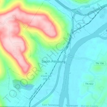
Nombre: Mapa topográfico South Pittsburg, altitud, relieve.
Altitud media: 272 m
Altitud mínima: 176 m
Altitud máxima: 539 m
Haz una donación
Otros mapas topográficos
Haga clic en un mapa para ver su topografía, su altitud y su relieve.