
Mapa topográfico Harrington
Mapa interactivo
Haga clic en el mapa para ver la altitud.
Acerca de este mapa
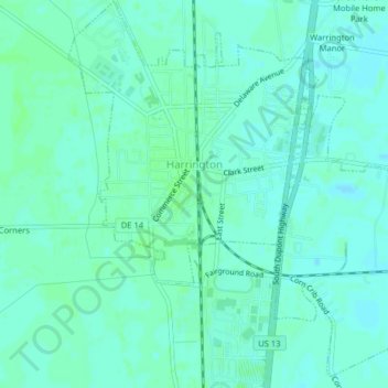
Nombre: Mapa topográfico Harrington, altitud, relieve.
Lugar: Harrington, Kent County, Delaware, United States (38.90579 -75.59069 38.93679 -75.55149)
Altitud media: 17 m
Altitud mínima: 14 m
Altitud máxima: 20 m
Otros mapas topográficos
Haga clic en un mapa para ver su topografía, su altitud y su relieve.
Camden
United States > Delaware > Kent County
Camden, Kent County, Delaware, United States
Altitud media: 13 m
Holletts Corners
United States > Delaware > Kent County
Holletts Corners, Kent County, Delaware, United States
Altitud media: 21 m
Woodstock Court
United States > Delaware > Kent County > Dover
Woodstock Court, Dover, Kent County, Delaware, 19904, United States
Altitud media: 13 m
Lake Bernard
United States > Delaware > Kent County > Florence
Lake Bernard, Florence, Kent County, Delaware, United States
Altitud media: 4 m
Marydel
United States > Delaware > Kent County
Marydel, Kent County, Delaware, 19964, United States
Altitud media: 19 m
Cheswold
United States > Delaware > Kent County
Cheswold, Kent County, Delaware, 19936, United States
Altitud media: 13 m
Cheswold
United States > Delaware > Kent County > Cheswold
Cheswold, Kent County, Delaware, 19936, United States
Altitud media: 13 m
Tidbury Manor
United States > Delaware > Kent County > Tidbury Manor
Tidbury Manor, Kent County, Delaware, 19901:19962, United States
Altitud media: 8 m
Felton
United States > Delaware > Kent County
Felton, Kent County, Delaware, United States
Altitud media: 18 m
Dover
United States > Delaware > Kent County
Dover, Kent County, Delaware, United States
Altitud media: 10 m