
Gracias por apoyar a este sitio ❤️
Haz una donación
Haz una donación
Mapa topográfico Ramona
Haga clic en el mapa para ver la altitud.
Gracias por apoyar a este sitio ❤️
Haz una donación
Haz una donación
Ramona
In January 2006, Ramona Valley was designated the country's 162nd American Viticultural Area (AVA) by the Alcohol and Tobacco Tax and Trade Bureau, which recognized the area for its distinctive microclimate, elevation, and soil attributes.
Gracias por apoyar a este sitio ❤️
Haz una donación
Haz una donación
Acerca de este mapa
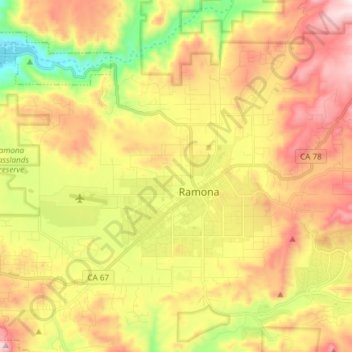
Nombre: Mapa topográfico Ramona, altitud, relieve.
Lugar: Ramona, San Diego County, California, 92065, United States (32.99768 -116.95744 33.09679 -116.80751)
Altitud media: 467 m
Altitud mínima: 128 m
Altitud máxima: 809 m
Gracias por apoyar a este sitio ❤️
Haz una donación
Haz una donación