
Mapa topográfico Montague Township
Mapa interactivo
Haga clic en el mapa para ver la altitud.
Acerca de este mapa
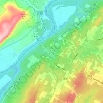
Nombre: Mapa topográfico Montague Township, altitud, relieve.
Lugar: Montague Township, Sussex County, New Jersey, United States (41.28315 -74.81350 41.32315 -74.77350)
Altitud media: 178 m
Altitud mínima: 104 m
Altitud máxima: 301 m
Montague Township is a township in Sussex County, in the U.S. state of New Jersey, in the New York City Metropolitan Area. As of the 2020 United States census, the township's population was 3,792, a decrease of 55 (−1.4%) from the 2010 census count of 3,847, which in turn reflected an increase of 435 (+12.7%) from the 3,412 counted in the 2000 census. High Point, within Montague Township, is the highest elevation within New Jersey at an altitude of 1,803 feet (550 m) above sea level. Montague is also the northernmost municipality in the state of New Jersey.
Otros mapas topográficos
Haga clic en un mapa para ver su topografía, su altitud y su relieve.
High Point State Park
United States > New Jersey > Sussex County > Montague Township
High Point State Park, Montague Township, Sussex County, New Jersey, 07827, United States
Altitud media: 255 m