
Mapa topográfico Isle Royale
Mapa interactivo
Haga clic en el mapa para ver la altitud.
Acerca de este mapa
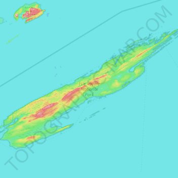
Nombre: Mapa topográfico Isle Royale, altitud, relieve.
Lugar: Isle Royale, Keweenaw County, Michigan, United States (47.82376 -89.23555 48.19102 -88.42232)
Altitud media: 190 m
Altitud mínima: 176 m
Altitud máxima: 443 m
According to the Köppen climate classification system, Isle Royale National Park has a mild summer Humid continental climate (Dfb). According to the United States Department of Agriculture, the Plant Hardiness zone is 4b at 1178 ft (359 m) elevation with an average annual extreme minimum temperature of -24.2 °F (-31.2 °C).
Otros mapas topográficos
Haga clic en un mapa para ver su topografía, su altitud y su relieve.
Grant Township
United States > Michigan > Keweenaw County
Grant Township, Keweenaw County, Michigan, 49918, United States
Altitud media: 220 m