
Mapa topográfico Whitefish Dunes State Park
Mapa interactivo
Haga clic en el mapa para ver la altitud.
Acerca de este mapa
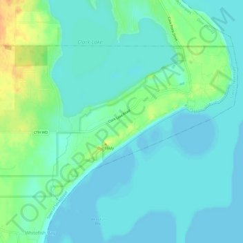
Nombre: Mapa topográfico Whitefish Dunes State Park, altitud, relieve.
Altitud media: 181 m
Altitud mínima: 172 m
Altitud máxima: 207 m
Otros mapas topográficos
Haga clic en un mapa para ver su topografía, su altitud y su relieve.
Potawatomi State Park
United States > Wisconsin > Door County > Sturgeon Bay
Potawatomi State Park, North Duluth Avenue, Sturgeon Bay, Town of Nasewaupee, Door County, Wisconsin, 54235, United States
Altitud media: 195 m