
Mapa topográfico Pullman
Mapa interactivo
Haga clic en el mapa para ver la altitud.
Acerca de este mapa
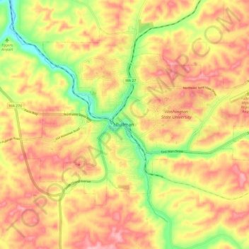
Nombre: Mapa topográfico Pullman, altitud, relieve.
Altitud media: 774 m
Altitud mínima: 693 m
Altitud máxima: 832 m
The city is situated across several loess hills which characterize the Palouse Prairie, formed from windblown sediment over an estimated period of over one million years. This prairie region, the Palouse, is noteworthy for its fertile rolling hills where winter and spring wheat, barley, lentils, and peas are grown. These hills provide a variety of elevations across the city, from 2342 to 2575 ft (714 to 785 m) above sea level. Downtown Pullman is situated in a valley between these hills. Within the Pullman city limits, the Missouri Flat Creek and Paradise Creek both join the South Fork of the Palouse River. Pullman sits in the watersheds of the Snake River and the Columbia River.