
Gracias por apoyar a este sitio ❤️
Haz una donación
Haz una donación
Mapa topográfico Mali Povlen
Haga clic en el mapa para ver la altitud.
Gracias por apoyar a este sitio ❤️
Haz una donación
Haz una donación
Acerca de este mapa
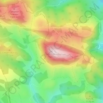
Nombre: Mapa topográfico Mali Povlen, altitud, relieve.
Altitud media: 1.139 m
Altitud mínima: 968 m
Altitud máxima: 1.338 m
Gracias por apoyar a este sitio ❤️
Haz una donación
Haz una donación
Otros mapas topográficos
Haga clic en un mapa para ver su topografía, su altitud y su relieve.
Gornja Polosnica
Serbia > Zlatibor Administrative District > Kosjeric Municipality
Altitud media: 655 m
Gracias por apoyar a este sitio ❤️
Haz una donación
Haz una donación
Kosjerić (town)
Serbia > Zlatibor Administrative District > Kosjeric Municipality
Kosjeríć (Serbian Cyrillic: Косјерић, pronounced [kɔsjɛ̌rit͡ɕ]) is a town and municipality located in the Zlatibor District of western Serbia. The municipality has a population of 10,175 inhabitants and the town itself has 3,723 (2022 census). The municipality's area is 359 square kilometres…
Altitud media: 465 m