Mapa topográfico Demorest
Mapa interactivo
Haga clic en el mapa para ver la altitud.
Acerca de este mapa
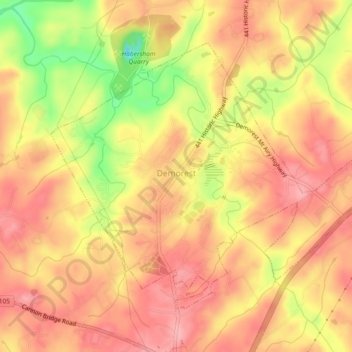
Nombre: Mapa topográfico Demorest, altitud, relieve.
Lugar: Demorest, Habersham County, Georgia, United States (34.55048 -83.56181 34.57932 -83.51570)
Altitud media: 416 m
Altitud mínima: 337 m
Altitud máxima: 455 m
Otros mapas topográficos
Haga clic en un mapa para ver su topografía, su altitud y su relieve.
Tugaloo
United States > Georgia > Habersham County > Tallulah Falls
Tugaloo, Tallulah Falls, Habersham County, Georgia, United States
Altitud media: 392 m
Turnerville
United States > Georgia > Habersham County
Turnerville, Habersham County, Georgia, 30580, United States
Altitud media: 463 m
Habersham
United States > Georgia > Habersham County
Habersham, Habersham County, Georgia, 30544, United States
Altitud media: 409 m
Baldwin
United States > Georgia > Habersham County
Baldwin, Habersham County, Georgia, United States
Altitud media: 395 m
Clarkesville
United States > Georgia > Habersham County
Clarkesville, Habersham County, Georgia, United States
Altitud media: 418 m
Mount Airy
United States > Georgia > Habersham County
Mount Airy, Habersham County, Georgia, United States
Altitud media: 443 m
Apple Pie Mountain
United States > Georgia > Habersham County
Apple Pie Mountain, Habersham County, Georgia, 30573, United States
Altitud media: 537 m
Cornelia
United States > Georgia > Habersham County
Cornelia, Habersham County, Georgia, United States
Altitud media: 446 m
Tallulah Falls
United States > Georgia > Habersham County
Tallulah Falls, Habersham County, Georgia, United States
Altitud media: 488 m