
Gracias por apoyar a este sitio ❤️
Haz una donación
Haz una donación
Mapa topográfico Mascot
Haga clic en el mapa para ver la altitud.
Gracias por apoyar a este sitio ❤️
Haz una donación
Haz una donación
Acerca de este mapa
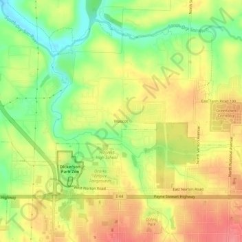
Nombre: Mapa topográfico Mascot, altitud, relieve.
Lugar: Mascot, Greene County, Missouri, 65803, United States (37.24282 -93.31686 37.28282 -93.27686)
Altitud media: 376 m
Altitud mínima: 334 m
Altitud máxima: 410 m
Gracias por apoyar a este sitio ❤️
Haz una donación
Haz una donación
Otros mapas topográficos
Haga clic en un mapa para ver su topografía, su altitud y su relieve.
Gracias por apoyar a este sitio ❤️
Haz una donación
Haz una donación
Strafford
United States > Missouri > Greene County
According to the United States Census Bureau, the city has a total area of 2.63 square miles (6.81 km2), all land. USGS Department of the Interior Original Survey 1838 and USGS Topographical Maps show the town along the White River Road that became the Telegraph Road to Saint Louis.
Altitud media: 437 m
Gracias por apoyar a este sitio ❤️
Haz una donación
Haz una donación