
Mapa topográfico Beijing
Mapa interactivo
Haga clic en el mapa para ver la altitud.
Acerca de este mapa
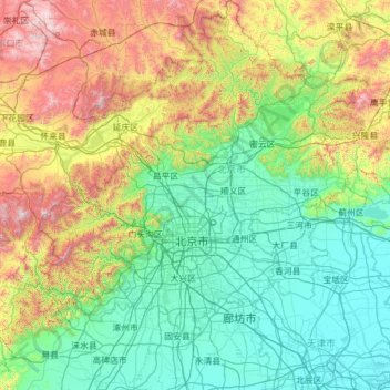
Nombre: Mapa topográfico Beijing, altitud, relieve.
Lugar: Beijing, China (39.44161 115.41721 41.05956 117.50799)
Altitud media: 492 m
Altitud mínima: 1 m
Altitud máxima: 2.218 m
Beijing is situated at the northern tip of the roughly triangular North China Plain, which opens to the south and east of the city. Mountains to the north, northwest and west shield the city and northern China's agricultural heartland from the encroaching desert steppes. The northwestern part of the municipality, especially Yanqing County and Huairou District, are dominated by the Jundu Mountains, while the western part is framed by Xishan or the Western Hills. The Great Wall of China across the northern part of Beijing Municipality was built on the rugged topography to defend against nomadic incursions from the steppes. Mount Dongling, in the Western Hills and on the border with Hebei, is the municipality's highest point, with an altitude of 2,303 metres (7,556 ft).
Otros mapas topográficos
Haga clic en un mapa para ver su topografía, su altitud y su relieve.