
Gracias por apoyar a este sitio ❤️
Haz una donación
Haz una donación
Mapa topográfico Bandarban
Haga clic en el mapa para ver la altitud.
Gracias por apoyar a este sitio ❤️
Haz una donación
Haz una donación
Acerca de este mapa
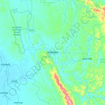
Nombre: Mapa topográfico Bandarban, altitud, relieve.
Altitud media: 78 m
Altitud mínima: 2 m
Altitud máxima: 606 m
Gracias por apoyar a este sitio ❤️
Haz una donación
Haz una donación
Otros mapas topográficos
Haga clic en un mapa para ver su topografía, su altitud y su relieve.
Sitakunda Upazila
Bangladesh > Chattogram Division
Sitakunda Upazila occupies an area of 483.97 square kilometres (186.86 sq mi), which includes 61.61 square kilometres (23.79 sq mi) of forest. It is bordered by Mirsharai to the north, Pahartali to the south, Fatickchhari, Hathazari and Panchlaish to the east, and the Sandwip Channel in the Bay of Bengal to…
Altitud media: 15 m
Gracias por apoyar a este sitio ❤️
Haz una donación
Haz una donación
Rajeshpur Eco-Park
Bangladesh > Chattogram Division > Cumilla Adarsha Sadar Upazila
Altitud media: 15 m
Gracias por apoyar a este sitio ❤️
Haz una donación
Haz una donación