
Mapa topográfico Gobertange
Mapa interactivo
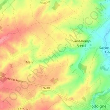
Haga clic en el mapa para ver la altitud.
Acerca de este mapa
Nombre: Mapa topográfico Gobertange, altitud, relieve.
Altitud media: 98 m
Altitud mínima: 56 m
Altitud máxima: 132 m
Otros mapas topográficos
Haga clic en un mapa para ver su topografía, su altitud y su relieve.
Piétrain
Belgique > Brabant wallon > Nivelles > Jodoigne
Piétrain, Jodoigne, Nivelles, Brabant wallon, Wallonie, Belgique
Altitud media: 90 m
Arbre de la liberté
Belgique > Brabant wallon > Nivelles > Jodoigne
Arbre de la liberté, Grand'Place, Les Rendanges, Jodoigne, Nivelles, Brabant wallon, Wallonie, 1370, Belgique
Altitud media: 85 m
Saint-Jean-Geest
Belgique > Brabant wallon > Nivelles > Jodoigne
Saint-Jean-Geest, Jodoigne, Nivelles, Brabant wallon, Wallonie, 1370, Belgique
Altitud media: 82 m
Sainte-Marie-Geest
Belgique > Brabant wallon > Nivelles > Jodoigne > Sainte-Marie-Geest
Sainte-Marie-Geest, Jodoigne, Nivelles, Brabant wallon, Wallonie, 1370, Belgique
Altitud media: 82 m