
Mapa topográfico Saluda
Mapa interactivo
Haga clic en el mapa para ver la altitud.
Acerca de este mapa
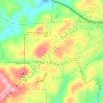
Nombre: Mapa topográfico Saluda, altitud, relieve.
Lugar: Saluda, Polk County, North Carolina, 28773, United States (35.22812 -82.36302 35.25086 -82.32559)
Altitud media: 635 m
Altitud mínima: 498 m
Altitud máxima: 735 m
Saluda is located in southwestern Polk County at 35°14′16″N 82°20′49″W / 35.237856°N 82.346870°W / 35.237856; -82.346870 (35.237856, -82.346870). Two small parts of the city extend west and north into Henderson County. The elevation on Main Street is 2,097 feet (639 m) above sea level, while the elevation at the bottom end of the Saluda Grade, in Tryon, is 1,080 feet (329.1 m).
Otros mapas topográficos
Haga clic en un mapa para ver su topografía, su altitud y su relieve.
Peniel
United States > North Carolina > Polk County
Peniel, Polk County, North Carolina, 28722, United States
Altitud media: 326 m
Tryon
United States > North Carolina > Polk County
Tryon, Polk County, North Carolina, United States
Altitud media: 333 m
Howard Gap
United States > North Carolina > Polk County
Howard Gap, Polk County, North Carolina, United States
Altitud media: 573 m