
Haz una donación
Mapa topográfico Kauai
Haga clic en el mapa para ver la altitud.
Haz una donación
Kauai
Kauai, known as the "Garden Isle," features a remarkably diverse topography shaped by its volcanic origins and extensive erosion over millions of years. The island is characterized by a central mountainous region, dominated by the towering 5,148-foot Mount Waiʻaleʻale, one of the wettest places on Earth, and the dramatic cliffs of the Na Pali Coast, which rise steeply from the ocean and are adorned with lush valleys and hidden waterfalls. The island's terrain includes deep canyons, such as the stunning Waimea Canyon, often referred to as the "Grand Canyon of the Pacific," where steep red and green walls showcase the effects of erosion. This varied landscape not only creates breathtaking vistas but also supports a rich diversity of ecosystems, from tropical rainforests to coastal beaches, making Kauai a unique and captivating destination.
Haz una donación
Acerca de este mapa
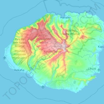
Nombre: Mapa topográfico Kauai, altitud, relieve.
Lugar: Kauai, Kauaʻi County, Hawaii, United States (21.86822 -159.78796 22.23271 -159.29232)
Altitud media: 216 m
Altitud mínima: 0 m
Altitud máxima: 1.568 m
Haz una donación
Otros mapas topográficos
Haga clic en un mapa para ver su topografía, su altitud y su relieve.
Haz una donación
Haz una donación
Haz una donación
Haz una donación