
Mapa topográfico Ketchum
Mapa interactivo
Haga clic en el mapa para ver la altitud.
Acerca de este mapa
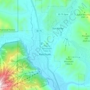
Nombre: Mapa topográfico Ketchum, altitud, relieve.
Lugar: Ketchum, Blaine County, Idaho, United States (43.65955 -114.41189 43.71297 -114.35118)
Altitud media: 1.906 m
Altitud mínima: 1.742 m
Altitud máxima: 2.671 m
After the mining boom subsided in the 1890s, sheepmen from the south drove their flocks north through Ketchum in the summer, to graze in the upper elevation areas of the Pioneer, Boulder, and Sawtooth mountains. By 1920, Ketchum had become the largest sheep-shipping center in the West. In the fall, massive flocks of sheep flowed south into the town's livestock corrals at the Union Pacific Railroad's railhead, which connected to the main line at Shoshone.
Otros mapas topográficos
Haga clic en un mapa para ver su topografía, su altitud y su relieve.
Carey
United States > Idaho > Blaine County
Carey, Blaine County, Idaho, 83320, United States
Altitud media: 1.467 m
Sun Valley
United States > Idaho > Blaine County
Sun Valley, Blaine County, Idaho, United States
Altitud media: 1.988 m
Titus Lake
United States > Idaho > Blaine County
Titus Lake, Blaine County, Idaho, United States
Altitud media: 2.736 m
Bellevue
United States > Idaho > Blaine County
Bellevue, Blaine County, Idaho, 83313, United States
Altitud media: 1.667 m
Hailey
United States > Idaho > Blaine County
Hailey, Blaine County, Idaho, 83333, United States
Altitud media: 1.729 m