
Mapa topográfico Hentland
Mapa interactivo
Haga clic en el mapa para ver la altitud.
Acerca de este mapa
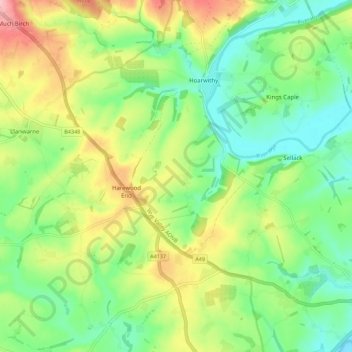
Nombre: Mapa topográfico Hentland, altitud, relieve.
Lugar: Hentland, Harewood End, Herefordshire, England, United Kingdom (51.90719 -2.69395 51.97594 -2.64377)
Altitud media: 85 m
Altitud mínima: 29 m
Altitud máxima: 177 m
Otros mapas topográficos
Haga clic en un mapa para ver su topografía, su altitud y su relieve.
Michaelchurch
United Kingdom > England > Herefordshire > Harewood End
Michaelchurch, Tretire with Michaelchurch, Harewood End, Herefordshire, England, HR2 8LD, United Kingdom
Altitud media: 90 m