
Haz una donación
Mapa topográfico North Industry
Haga clic en el mapa para ver la altitud.
Haz una donación
Acerca de este mapa
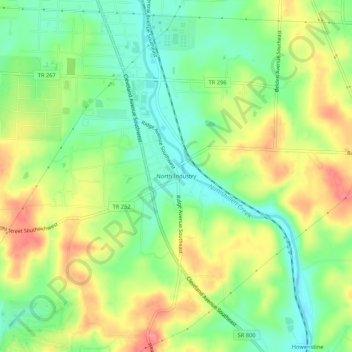
Nombre: Mapa topográfico North Industry, altitud, relieve.
Lugar: North Industry, Stark County, Ohio, 44707, United States (40.71895 -81.38678 40.75895 -81.34678)
Altitud media: 333 m
Altitud mínima: 295 m
Altitud máxima: 382 m
Haz una donación
Otros mapas topográficos
Haga clic en un mapa para ver su topografía, su altitud y su relieve.
Canton
United States > Ohio > Stark County
Canton is located at an elevation of 1,060 feet (323 m). Nimishillen Creek and its East, Middle and West Branches flow through the city.
Altitud media: 335 m
Haz una donación
Haz una donación
Haz una donación
Canton
United States > Ohio > Stark County
Canton is located at an elevation of 1,060 feet (323 m). Nimishillen Creek and its East, Middle and West Branches flow through the city.
Altitud media: 335 m
Haz una donación
Canton
United States > Ohio > Stark County
Canton is located at an elevation of 1,060 feet (323 m).[39] Nimishillen Creek and its East, Middle and West Branches flow through the city.[40]
Altitud media: 335 m