
Mapa topográfico Black Elk Peak
Mapa interactivo
Haga clic en el mapa para ver la altitud.
Acerca de este mapa
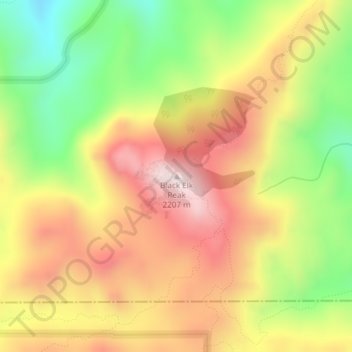
Nombre: Mapa topográfico Black Elk Peak, altitud, relieve.
Altitud media: 1.923 m
Altitud mínima: 1.634 m
Altitud máxima: 2.185 m
Black Elk Peak is the highest natural point in the U.S. state of South Dakota and the Midwestern United States. It lies in the Black Elk Wilderness area, in southern Pennington County, in the Black Hills National Forest. The peak lies 3.7 mi (6.0 km) west-southwest of Mount Rushmore. At 7,244 feet (2,208 m), it has been described by the Board on Geographical Names as the highest summit in the United States east of the Rocky Mountains. Though part of the North American Cordillera, it is generally considered to be geologically separate from the Rocky Mountains. Lost Mine peak in the Chisos Mountains of Texas, at an elevation of 7,535 feet, is the easternmost peak within the continental United States above 7,000 feet.
Otros mapas topográficos
Haga clic en un mapa para ver su topografía, su altitud y su relieve.
Rapid City
United States > South Dakota > Pennington County
Rapid City, Pennington County, South Dakota, United States
Altitud media: 1.068 m
Black Hills
United States > South Dakota > Pennington County
Black Hills, Pennington County, South Dakota, United States
Altitud media: 1.894 m
Mount Rushmore National Memorial
United States > South Dakota > Pennington County
Mount Rushmore National Memorial, Pennington County, South Dakota, United States
Altitud media: 1.528 m
Colonial Pine Hills
United States > South Dakota > Pennington County
Colonial Pine Hills, Pennington County, South Dakota, United States
Altitud media: 1.232 m
Thrall Mountain
United States > South Dakota > Pennington County
Thrall Mountain, Pennington County, South Dakota, United States
Altitud media: 1.392 m
Scenic
United States > South Dakota > Pennington County
Scenic, Pennington County, South Dakota, 57780, United States
Altitud media: 853 m
Horse Thief Lake
United States > South Dakota > Pennington County
Horse Thief Lake, Pennington County, South Dakota, United States
Altitud media: 1.564 m
Silver City
United States > South Dakota > Pennington County
Silver City, Pennington County, South Dakota, United States
Altitud media: 1.495 m
Copper Mountain
United States > South Dakota > Pennington County
Copper Mountain, West Pennington, Pennington County, South Dakota, United States
Altitud media: 2.006 m
Wall
United States > South Dakota > Pennington County
Wall, Pennington County, South Dakota, 57790, United States
Altitud media: 854 m
Box Elder
United States > South Dakota > Pennington County
Box Elder, Pennington County, South Dakota, United States
Altitud media: 968 m
Hill City
United States > South Dakota > Pennington County
Hill City, Pennington County, South Dakota, United States
Altitud media: 1.571 m
Warbonnet
United States > South Dakota > Pennington County > Warbonnet
Warbonnet, Pennington County, South Dakota, United States
Altitud media: 966 m