
Mapa topográfico Staten Island
Mapa interactivo
Haga clic en el mapa para ver la altitud.
Acerca de este mapa
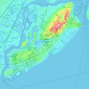
Nombre: Mapa topográfico Staten Island, altitud, relieve.
Lugar: Staten Island, Richmond County, New York, United States (40.47658 -74.25884 40.65151 -74.03461)
Altitud media: 9 m
Altitud mínima: -5 m
Altitud máxima: 121 m
Although Staten Island is a borough of New York City, the island is topographically and geologically a part of New Jersey. Staten Island is separated from Long Island by the Narrows and from mainland New Jersey by the Arthur Kill and the Kill Van Kull. Staten Island is positioned at the center of New York Bight, a sharp bend in the shoreline between New Jersey and Long Island. The region is considered vulnerable to sea-level rise. On October 29, 2012, the island experienced severe damage and loss of life along with the destruction of many homes during Hurricane Sandy.
Otros mapas topográficos
Haga clic en un mapa para ver su topografía, su altitud y su relieve.
Brooklyn
United States > New York > New York
Brooklyn, Kings County, New York, United States
Altitud media: 9 m
Queens County
United States > New York > New York
Queens County, New York, United States
Altitud media: 11 m
Bronx County
United States > New York > New York
Bronx County, The Bronx, New York, United States
Altitud media: 21 m
Kaiser Park
United States > New York > New York
Kaiser Park, Brooklyn, Kings County, New York, United States
Altitud media: 2 m
Franz Sigel Park
United States > New York > New York
Franz Sigel Park, Bronx County, The Bronx, New York, United States
Altitud media: 16 m
Emerson Hill
United States > New York > New York
Emerson Hill, New York, 10304, United States
Altitud media: 53 m
Sylvan Water
United States > New York > New York
Sylvan Water, Brooklyn, Kings County, New York, United States
Altitud media: 25 m
Jackie Robinson Park
United States > New York > New York
Jackie Robinson Park, Brooklyn, Kings County, New York, United States
Altitud media: 22 m
Queens
United States > New York > New York
Queens, Queens County, New York, United States
Altitud media: 12 m
Lawrence Point
United States > New York > New York
Lawrence Point, Queens County, New York, 11105, United States
Altitud media: 4 m
Flushing Bay
United States > New York > New York
Flushing Bay, Queens County, New York, 11356, United States
Altitud media: 4 m
Gowanus Canal
United States > New York > New York
Gowanus Canal, Kings County, New York, 11231, United States
Altitud media: 11 m
Fort Greene Park
United States > New York > New York
Fort Greene Park, Brooklyn, Kings County, New York, United States
Altitud media: 17 m
New York County
United States > New York > New York
New York County, New York, United States
Altitud media: 16 m
Prospect Park
United States > New York > New York
Prospect Park, Kings County, New York, United States
Altitud media: 34 m
Flushing Meadows-Corona Park
United States > New York > New York
Flushing Meadows-Corona Park, New York, United States
Altitud media: 15 m
Willets Point
United States > New York > New York
Willets Point, Queens County, New York, 11359, United States
Altitud media: 2 m
Jamaica Bay Wildlife Refuge
United States > New York > New York
Jamaica Bay Wildlife Refuge, Queens County, New York, 11694, United States
Altitud media: 1 m
Flushing Meadows Scenic Viewpoint
United States > New York > New York
Flushing Meadows Scenic Viewpoint, Pat Dolan Trail, Kew Gardens, Queens, New York, 11375, United States
Altitud media: 22 m
Coastline access
United States > New York > New York
Coastline access, Brooklyn, Kings County, New York, United States
Altitud media: 3 m
Bowery Bay
United States > New York > New York
Bowery Bay, Queens County, New York, 11371, United States
Altitud media: 5 m
Richmond County
United States > New York > New York
Richmond County, New York, United States
Altitud media: 9 m
Kings County
United States > New York > New York
Kings County, New York, United States
Altitud media: 9 m
Barren Island
United States > New York > New York
Barren Island, New York, 11697, United States
Altitud media: 16 m