
Haz una donación
Mapa topográfico Dartmouth
Haga clic en el mapa para ver la altitud.
Haz una donación
Dartmouth
The highest point in the town is near its northwest corner, where the elevation rises to over 256 feet (78 m) above sea level north of Old Fall River Road.
Haz una donación
Acerca de este mapa
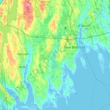
Nombre: Mapa topográfico Dartmouth, altitud, relieve.
Lugar: Dartmouth, Bristol County, Massachusetts, United States (41.50457 -71.07667 41.73401 -70.92130)
Altitud media: 21 m
Altitud mínima: -22 m
Altitud máxima: 105 m
Haz una donación
Otros mapas topográficos
Haga clic en un mapa para ver su topografía, su altitud y su relieve.
Leonard and Marydee Flynn Cons Area
United States > Massachusetts > Bristol County > Mansfield
Altitud media: 39 m
Haz una donación
Haz una donación
Haz una donación
Haz una donación
Source Is Shapefile From Town
United States > Massachusetts > Bristol County > Mansfield > Robinsonville
Altitud media: 50 m
Daley Corner
United States > Massachusetts > Bristol County > Easton > North Easton
Altitud media: 47 m
Haz una donación
Haz una donación
Haz una donación
Source Is Shapefile From Town
United States > Massachusetts > Bristol County > Mansfield > Robinsonville
Altitud media: 50 m
Haz una donación