
Gracias por apoyar a este sitio ❤️
Haz una donación
Haz una donación
Mapa topográfico Noble
Haga clic en el mapa para ver la altitud.
Gracias por apoyar a este sitio ❤️
Haz una donación
Haz una donación
Acerca de este mapa
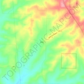
Nombre: Mapa topográfico Noble, altitud, relieve.
Lugar: Noble, Ozark County, Missouri, 65715, United States (36.72756 -92.58989 36.76756 -92.54989)
Altitud media: 325 m
Altitud mínima: 277 m
Altitud máxima: 384 m
Gracias por apoyar a este sitio ❤️
Haz una donación
Haz una donación
Otros mapas topográficos
Haga clic en un mapa para ver su topografía, su altitud y su relieve.
Bull Shoals Lake
United States > Missouri > Ozark County > Theodosia
Bull Shoals Lake impounds the White River for the last time as water travels toward its mouth on the Mississippi River. Bull Shoals is thus the lake farthest downstream in a chain of four artificial lakes that include (from upstream to downstream) Beaver Lake, Table Rock Lake and Lake Taneycomo. The lake is…
Altitud media: 280 m