
Haz una donación
Mapa topográfico Oʻahu
Haga clic en el mapa para ver la altitud.
Haz una donación
Oʻahu
Oʻahu exhibits a striking and diverse topography shaped primarily by its volcanic origins and subsequent erosion. The island features a rugged landscape dominated by two prominent volcanic mountains, Koʻolau and Waiʻanae, which rise sharply from the coastline, reaching elevations of approximately 4,000 feet. The windward sides of these ranges are characterized by lush, steep valleys and numerous waterfalls, shaped by heavy rainfall and the erosive power of streams cutting through the basalt rock. In contrast, the leeward coasts present a more gentle terrain, with flatter areas and sandy beaches, where erosion is less pronounced due to lower precipitation levels. Oʻahu's unique topography is further highlighted by features such as the dramatic cliffs known as "pali," formed by past volcanic activity and landslides, which have also created striking coastal scenery along the island's shores.
Haz una donación
Acerca de este mapa
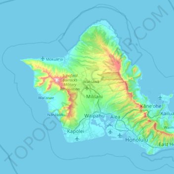
Nombre: Mapa topográfico Oʻahu, altitud, relieve.
Lugar: Oʻahu, Honolulu County, Hawaii, United States (21.25482 -158.28058 21.71201 -157.64863)
Altitud media: 79 m
Altitud mínima: -3 m
Altitud máxima: 1.225 m
Haz una donación
Otros mapas topográficos
Haga clic en un mapa para ver su topografía, su altitud y su relieve.
Waipahu
United States > Hawaii > Honolulu County
There are several streams that run through Waipahu, including Waikele Stream and Kapakahi Stream. Waikele Stream runs along the Hawaii Plantation Village and down into Pouhala Marsh Wildlife Sanctuary, which is habitat for several endangered bird species that are endemic to Hawaii. There is roughly 140 feet of…
Altitud media: 164 m
Waimānalo Beach Park
United States > Hawaii > Honolulu County > East Honolulu > Waimanalo
Altitud media: 55 m
Haz una donación
Haz una donación
Haz una donación
Palolo Valley Recreational Park
United States > Hawaii > Honolulu County > East Honolulu
Altitud media: 144 m
Haz una donación
Haz una donación
Hanauma Bay
United States > Hawaii > Honolulu County
Approximately 3.9 million years ago, the Waiʻanae volcano created the island of Oʻahu. About 2.5 million years ago, the Koʻolau volcano breached the ocean's surface and continued to grow in elevation until about 1.7 million years ago, when it went dormant. Most of the eastern or windward portion of Oʻahu…
Altitud media: 32 m
Haz una donación
Haz una donación
Haz una donación
Waipahu
United States > Hawaii > Honolulu County
There are several streams that run through Waipahu, including Waikele Stream and Kapakahi Stream. Waikele Stream runs along the Hawaii Plantation Village and down into Pouhala Marsh Wildlife Sanctuary, which is habitat for several endangered bird species that are endemic to Hawaii. There is roughly 140 feet of…
Altitud media: 164 m
Haz una donación
Haz una donación
Haz una donación
Waipahu
United States > Hawaii > Honolulu County
There are several streams that run through Waipahu, including Waikele Stream and Kapakahi Stream. Waikele Stream runs along the Hawaii Plantation Village and down into Pouhala Marsh Wildlife Sanctuary, which is habitat for several endangered bird species that are endemic to Hawaii. There is roughly 140 feet of…
Altitud media: 164 m
Haz una donación
Haz una donación