
Mapa topográfico West Richland
Mapa interactivo
Haga clic en el mapa para ver la altitud.
Acerca de este mapa
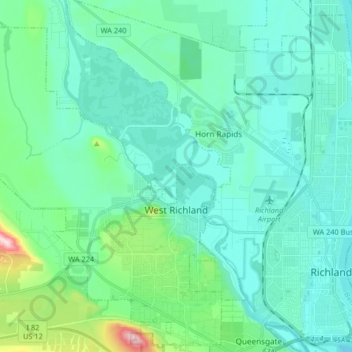
Nombre: Mapa topográfico West Richland, altitud, relieve.
Altitud media: 146 m
Altitud mínima: 93 m
Altitud máxima: 424 m
The original people of the region were the Chemnapum Indians (closely related to the Wanapum tribe), living near the mouth of the Yakima River. Lewis and Clark passed through the area in 1805, and an expedition of the Army Corps of Topographical Engineers headed by Robert E Johnson mapped the Yakima Valley in 1841.
Otros mapas topográficos
Haga clic en un mapa para ver su topografía, su altitud y su relieve.
Richland
United States > Washington > Benton County
Richland, Benton County, Washington, United States
Altitud media: 160 m
Kennewick
United States > Washington > Benton County
Kennewick, Benton County, Washington, United States
Altitud media: 154 m
Columbia Plateau
United States > Washington > Benton County
Columbia Plateau, Benton County, Washington, United States
Altitud media: 221 m