
Gracias por apoyar a este sitio ❤️
Haz una donación
Haz una donación
Mapa topográfico Heath
Haga clic en el mapa para ver la altitud.
Gracias por apoyar a este sitio ❤️
Haz una donación
Haz una donación
Acerca de este mapa
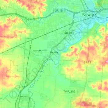
Nombre: Mapa topográfico Heath, altitud, relieve.
Lugar: Heath, Licking County, Ohio, United States (39.99028 -82.50248 40.05240 -82.37088)
Altitud media: 281 m
Altitud mínima: 241 m
Altitud máxima: 354 m
Gracias por apoyar a este sitio ❤️
Haz una donación
Haz una donación
Otros mapas topográficos
Haga clic en un mapa para ver su topografía, su altitud y su relieve.