
Gracias por apoyar a este sitio ❤️
Haz una donación
Haz una donación
Mapa topográfico Buc
Haga clic en el mapa para ver la altitud.
Gracias por apoyar a este sitio ❤️
Haz una donación
Haz una donación
Buc
The old town lies in the valley of the River Bièvre at an elevation of around 100 m above sea level. Most of Buc's residential districts have been built on the plateau de Saclay, some 50 m higher.
Gracias por apoyar a este sitio ❤️
Haz una donación
Haz una donación
Acerca de este mapa
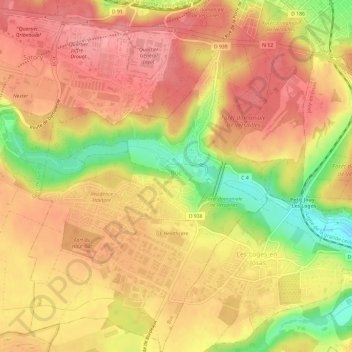
Nombre: Mapa topográfico Buc, altitud, relieve.
Altitud media: 151 m
Altitud mínima: 90 m
Altitud máxima: 183 m
Gracias por apoyar a este sitio ❤️
Haz una donación
Haz una donación
Otros mapas topográficos
Haga clic en un mapa para ver su topografía, su altitud y su relieve.
Le Champtier des Fourneaux
France > Ile-de-France > Yvelines > Dampierre-en-Yvelines
Altitud media: 143 m
Gracias por apoyar a este sitio ❤️
Haz una donación
Haz una donación
Val des Quatre Pignons
France > Ile-de-France > Yvelines > Beynes > Val des Quatre Pignons
Altitud media: 92 m
Gracias por apoyar a este sitio ❤️
Haz una donación
Haz una donación