
Haz una donación
Mapa topográfico North Salt Lake
Haga clic en el mapa para ver la altitud.
Haz una donación
Acerca de este mapa
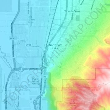
Nombre: Mapa topográfico North Salt Lake, altitud, relieve.
Lugar: North Salt Lake, Davis County, Utah, 84054, United States (40.81988 -111.96688 40.86616 -111.87234)
Altitud media: 1.429 m
Altitud mínima: 1.283 m
Altitud máxima: 1.942 m
Haz una donación
Otros mapas topográficos
Haga clic en un mapa para ver su topografía, su altitud y su relieve.
Antelope Island
United States > Utah > Davis County
The island is accessible via a 7-mile causeway from Syracuse in Davis County. Access from Interstate 15 is via exit 332, then west along Antelope Drive (SR-108). The island's shore (all but west side of the island) is mostly flat with beaches and plains to the base of the mountains on the island. These steep…
Altitud media: 1.306 m
Haz una donación
Haz una donación
Mount Lebannon Acres
United States > Utah > Davis County > Centerville > Rosedale
Altitud media: 1.464 m