
Haz una donación
Mapa topográfico Yalova
Haga clic en el mapa para ver la altitud.
Haz una donación
Acerca de este mapa
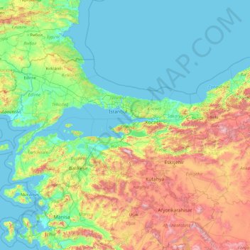
Nombre: Mapa topográfico Yalova, altitud, relieve.
Lugar: Yalova, Marmara Region, Turkey (37.97954 26.56870 43.17954 31.76870)
Altitud media: 404 m
Altitud mínima: -2 m
Altitud máxima: 2.703 m
Haz una donación
Otros mapas topográficos
Haga clic en un mapa para ver su topografía, su altitud y su relieve.
Haz una donación
Kaş
As the tenth largest district of Antalya as of 2021, Kaş is on a hill running down to the Turquoise Coast of southwestern Turkey. The district has a typical Mediterranean climate of hot, dry summers and mild, wet winters, which allows the growth of oranges, lemons and bananas. The lowland areas are also…
Altitud media: 837 m
Haz una donación
Haz una donación
Haz una donación
Antalya
The highest point of the Taurus mountains is Akdağ at an altitude of 3025 metres. Located to the northwest of the city centre and at a distance of 50 km (31 mi) is the Saklıkent ski and recreation centre on Beydağları. Here one can ski and then go down to the shore and into the sea during the months of…
Altitud media: 644 m
Haz una donación
Haz una donación
Anatolia
Anatolia (Turkish: Anadolu), also known as Asia Minor, is a peninsula in West Asia that makes up the majority of the land area of Turkey. It is the westernmost protrusion of Asia and is geographically bounded by the Mediterranean Sea to the south, the Aegean Sea to the west, the Turkish Straits to the…
Altitud media: 518 m
Haz una donación
Haz una donación
Antakya
Antakya's climate is classified as hot-summer Mediterranean (Köppen: Csa) or dry-summer humid subtropical (Trewartha: Cf or wet Cs). The city experiences hot, dry summers, and mild, wet winters; though its higher altitude allows for lower temperatures than the coast.
Altitud media: 385 m
Kaş
As the tenth largest district of Antalya as of 2021, Kaş is on a hill running down to the Turquoise Coast of southwestern Turkey. The district has a typical Mediterranean climate of hot, dry summers and mild, wet winters, which allows the growth of oranges, lemons and bananas. The lowland areas are also…
Altitud media: 837 m
Haz una donación
Taurus Mountains
The mountains have a Mediterranean climate, with dry summers and rainy winters. Temperatures vary with elevation, with warm winters on the lower coastal slopes and cold winters in the high mountains and in the interior.
Altitud media: 828 m
Haz una donación
Haz una donación
Haz una donación
Erdemli
Erdemli is a quiet rural district where the people are conservative, and is traditionally a stronghold of Turkish nationalist politicians; however some departments of Mersin University are opening branches here which will surely have an effect on the cultural and social life of Erdemli in the future. There is…
Altitud media: 966 m
Bağcılar
Bağcılar is located on the European side of Istanbul, within the service boundaries of Istanbul Metropolitan Municipality. Its area is 22 km2 (8.5 sq mi). The district is now known as an immigrant quarter. It lies between E-5 and TEM. In the south Bahçelievler, in the west Küçükçekmece, in the northwest…
Altitud media: 85 m
Haz una donación
Prince Islands
All islands contain hills, the highest being Büyükada's Aya Yorgi Hill with 203 meters of elevation.
Altitud media: 12 m
Haz una donación
Haz una donación
Haz una donación
Haz una donación
Çankaya Belediyesi Ahlatlıbel Atatürk Parkı Sosyal Tesisleri
Turkey > Ankara > Ankara > Çankaya
Altitud media: 1.199 m
Haz una donación
Haz una donación
Sivas
The city, which lies at an elevation of 1,278 metres (4,193 ft) in the broad valley of the Kızılırmak river, is a moderately-sized trade centre and industrial city, although the economy has traditionally been based on agriculture. Rail repair shops and a thriving manufacturing industry of rugs, bricks,…
Altitud media: 1.482 m
Şereflikoçhisar
Şereflikoçhisar, formerly known as Koçhisar, is a municipality and district of Ankara Province, Turkey. Its area is 2,155 km2, and its population is 33,140 (2022). It is 148 km south of the city of Ankara. Its average elevation ranges between 900 and 1,200 m, with the highest point being Mt. Karasenir at…
Altitud media: 1.009 m
Haz una donación
Zeytinburnu
Zeytinburnu is located on the part of Çatalca peninsula that is apart from historical peninsula with Walls of Constantinople and overlooks to the Marmara Sea in İstanbul. Its altitude generally increases from south to north, and in south districts (Sümer, Nuripaşa, Kazlıçeşme etc.) embankments, alluvium…
Altitud media: 37 m
Haz una donación
Haz una donación
Haz una donación
Ordu
Ordu is a strip of Black Sea coast and the hills behind, historically an agricultural and fishing area and in recent years, tourism has seen an increase, mainly visitors from Russia and Georgia, as Ordu boasts some of the best beaches, rivers, and lush, green mountains on the Black Sea coast. Walking in the…
Altitud media: 705 m
Anatolia
Anatolia (Turkish: Anadolu), also known as Asia Minor, is a peninsula in West Asia that makes up the majority of the land area of Turkey. It is the westernmost protrusion of Asia and is geographically bounded by the Mediterranean Sea to the south, the Aegean Sea to the west, the Turkish Straits to the…
Altitud media: 518 m
Haz una donación
Haz una donación