
Haz una donación
Mapa topográfico Schaumburg
Haga clic en el mapa para ver la altitud.
Haz una donación
Schaumburg
According to the 2021 census gazetteer files, Schaumburg has a total area of 19.47 square miles (50.43 km2), of which 19.35 square miles (50.12 km2) (or 99.39%) is land and 0.12 square miles (0.31 km2) (or 0.61%) is water. Its elevation varies between 750 and 850 feet above sea level, with a high point of 850 feet at the intersection of Schaumburg Road and Webster Lane. Schaumburg serves as the headwaters of the West Branch Dupage River, which drains the central and western portions of the village, flowing to the southwest. The West Branch of the Salt Creek drains the eastern portion of the village, flowing eastward into Busse Lake.
Haz una donación
Acerca de este mapa
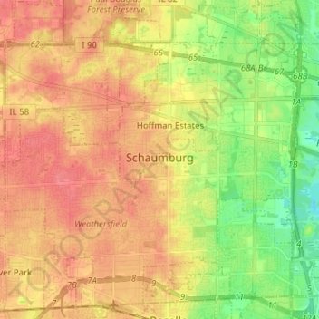
Nombre: Mapa topográfico Schaumburg, altitud, relieve.
Altitud media: 237 m
Altitud mínima: 204 m
Altitud máxima: 261 m
Haz una donación
Otros mapas topográficos
Haga clic en un mapa para ver su topografía, su altitud y su relieve.
Haz una donación
Haz una donación
Haz una donación
Haz una donación
Haz una donación
Chicago, North Shore & Milwaukee
United States > Illinois > Cook County > Northbrook > Williamsburg Square
Altitud media: 198 m
Haz una donación
Elmwood Park
United States > Illinois > Cook County > Elmwood Park > Elmwood Park
Altitud media: 194 m
Haz una donación