
Haz una donación
Mapa topográfico Topsfield
Haga clic en el mapa para ver la altitud.
Haz una donación
Topsfield
According to the United States Census Bureau, Topsfield has a total area of 12.8 square miles (33.2 km2), of which 11.9 square miles (30.9 km2) are land and 0.89 square miles (2.3 km2), or 7.00%, is water. Topsfield lies in the geographic center of Essex County, Massachusetts. Like its namesake in Essex, England, Topsfield has within its bounds some of the higher land in the county. The highest point in town is found on Great Hill, with an elevation of at least 245 feet (75 m), according to the most recent (2011-2012) USGS 7.5-minute topographical map. Hood's Pond, covering an area of 68 acres (28 ha) in the northern part of town, is the largest body of water in Topsfield, though most of it lies in Ipswich. Topsfield also includes parts of the Ipswich River Wildlife Sanctuary, Bradley Palmer State Park, Willowdale State Forest and the entirety of the Topsfield Town Forest.
Haz una donación
Acerca de este mapa
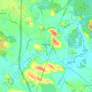
Nombre: Mapa topográfico Topsfield, altitud, relieve.
Lugar: Topsfield, Essex County, Massachusetts, 01983, United States (42.59949 -70.98532 42.67320 -70.89598)
Altitud media: 24 m
Altitud mínima: 5 m
Altitud máxima: 77 m
Haz una donación
Otros mapas topográficos
Haga clic en un mapa para ver su topografía, su altitud y su relieve.
Haz una donación
Haz una donación
Little River Marshes
United States > Massachusetts > Essex County > Gloucester > West Gloucester
Altitud media: 27 m
Blackwater River
United States > Massachusetts > Essex County > Salisbury > Salisbury Beach
Altitud media: 4 m
Haz una donación
Haz una donación
Haz una donación
Haz una donación
Haz una donación
Haz una donación
Haz una donación
Kettle Cove Village
United States > Massachusetts > Essex County > Manchester-by-the-Sea
Altitud media: 18 m
Haz una donación
Haz una donación
Haz una donación
Haz una donación
Haz una donación
Amesbury
United States > Massachusetts > Essex County > Amesbury
Amesbury is located at 42°51′29″N 70°55′50″W / 42.85806°N 70.93056°W / 42.85806; -70.93056. According to the United States Census Bureau, the city has a total area of 13.7 square miles (35.5 km2), of which 12.3 square miles (31.8 km2) is land and 1.5 square miles (3.8 km2), or 10.65%, is…
Altitud media: 24 m
East Parish
United States > Massachusetts > Essex County > Boxford > Boxford > East Parish
Altitud media: 38 m
Haz una donación
Haz una donación