
Haz una donación
Mapa topográfico East Lyme
Haga clic en el mapa para ver la altitud.
Haz una donación
East Lyme
The topography of East Lyme consists of rolling hills and lush valleys rounded by glaciers during the last Ice Age. Hills rise to elevations of 250 to 350 feet (76 to 107 m) above sea level in the eastern and central areas of the town. The highest point in town is an unnamed hill with an elevation of 500 feet (150 m) located in Nehantic State Forest in the northwest corner of the town. East Lyme is especially scenic in the summer when the trees are in bloom. On its east and southern sides, the town abuts tidewater. The tidal Niantic River on the east feeds Niantic Bay, an arm of Long Island Sound, which forms the southern edge of the town.
Haz una donación
Acerca de este mapa
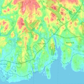
Nombre: Mapa topográfico East Lyme, altitud, relieve.
Altitud media: 41 m
Altitud mínima: -3 m
Altitud máxima: 152 m
Haz una donación
Otros mapas topográficos
Haga clic en un mapa para ver su topografía, su altitud y su relieve.
High Rock
United States > Connecticut > Southeastern Connecticut Planning Region > Waterford
Altitud media: 39 m
Chesterfield
United States > Connecticut > Southeastern Connecticut Planning Region > Montville
Altitud media: 77 m
North Franklin
United States > Connecticut > Southeastern Connecticut Planning Region
Altitud media: 103 m
Haz una donación
Flanders
United States > Connecticut > Southeastern Connecticut Planning Region > East Lyme
Altitud media: 43 m
Manitock Spring
United States > Connecticut > Southeastern Connecticut Planning Region > Waterford
Altitud media: 26 m
Quiambaug
United States > Connecticut > Southeastern Connecticut Planning Region > Mystic
Altitud media: 8 m
Oakdale
United States > Connecticut > Southeastern Connecticut Planning Region > Montville
Altitud media: 141 m
Haz una donación
Austrailia Beach
United States > Connecticut > Southeastern Connecticut Planning Region > Mystic
Altitud media: 19 m
Jordan Village
United States > Connecticut > Southeastern Connecticut Planning Region > Waterford
Altitud media: 27 m
Giants Neck
United States > Connecticut > Southeastern Connecticut Planning Region > East Lyme
Altitud media: 9 m
Uncasville
United States > Connecticut > Southeastern Connecticut Planning Region > Montville
Altitud media: 40 m
Haz una donación
Flanders
United States > Connecticut > Southeastern Connecticut Planning Region > East Lyme
Altitud media: 38 m
Pepperbox Hill
United States > Connecticut > Southeastern Connecticut Planning Region > Waterford
Altitud media: 18 m
Austrailia Beach
United States > Connecticut > Southeastern Connecticut Planning Region > Mystic
Altitud media: 19 m
Montville Center
United States > Connecticut > Southeastern Connecticut Planning Region > Montville
Altitud media: 106 m
Haz una donación
Four Corners
United States > Connecticut > Southeastern Connecticut Planning Region > Montville
Altitud media: 108 m
Taftville Reservoir #1 Dam
United States > Connecticut > Southeastern Connecticut Planning Region > Norwich
Altitud media: 75 m
Blue Lake
United States > Connecticut > Southeastern Connecticut Planning Region > North Stonington
Altitud media: 106 m
Haz una donación
Blackboys
United States > Connecticut > Southeastern Connecticut Planning Region > East Lyme
Altitud media: 38 m
Quiambaug
United States > Connecticut > Southeastern Connecticut Planning Region > Mystic
Altitud media: 8 m
Quaker Hill
United States > Connecticut > Southeastern Connecticut Planning Region > Waterford
Altitud media: 35 m
Center Groton
United States > Connecticut > Southeastern Connecticut Planning Region > Groton
Altitud media: 49 m
Haz una donación
Chesterfield
United States > Connecticut > Southeastern Connecticut Planning Region > Montville
Altitud media: 77 m
Austrailia Beach
United States > Connecticut > Southeastern Connecticut Planning Region > Mystic
Altitud media: 19 m
Huntley Island
United States > Connecticut > Southeastern Connecticut Planning Region > East Lyme
Altitud media: 7 m
Austrailia Beach
United States > Connecticut > Southeastern Connecticut Planning Region > Mystic
Altitud media: 19 m
Haz una donación
Hanover Reservoir
United States > Connecticut > Southeastern Connecticut Planning Region > Hanover
Altitud media: 91 m
North Stonington
United States > Connecticut > Southeastern Connecticut Planning Region
Altitud media: 73 m
Avery Hill
United States > Connecticut > Southeastern Connecticut Planning Region > Ledyard
Altitud media: 52 m
Mystic
United States > Connecticut > Southeastern Connecticut Planning Region > Stonington
Altitud media: 17 m
Haz una donación
Fitch Corner
United States > Connecticut > Southeastern Connecticut Planning Region > Montville
Altitud media: 51 m
Seal Rocks
United States > Connecticut > Southeastern Connecticut Planning Region > Stonington
Altitud media: 37 m