
Haz una donación
Mapa topográfico Kulathupuzha
Haga clic en el mapa para ver la altitud.
Haz una donación
Acerca de este mapa
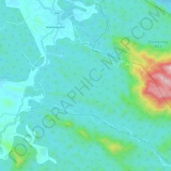
Nombre: Mapa topográfico Kulathupuzha, altitud, relieve.
Lugar: Kulathupuzha, Punalur, Kollam, Kerala, 691541, India (8.80393 77.04247 8.91548 77.14342)
Altitud media: 226 m
Altitud mínima: 103 m
Altitud máxima: 945 m
Haz una donación
Otros mapas topográficos
Haga clic en un mapa para ver su topografía, su altitud y su relieve.
Kasaragod
The district is the northernmost district of the State of Kerala. Kasargod is located at 12°30′N 75°00′E / 12.5°N 75.0°E / 12.5; 75.0. It has an average elevation of 19 metres (62 feet). Ranipuram or Madathumala (1016m) peak is the highest peak in the Kasargod district of Kerala, located in…
Altitud media: 127 m
Wayanad
Wayanad (IPA: [ʋɐjɐnaːɖɨ̆]) is a district in the north-east of Indian state Kerala with administrative headquarters at the municipality of Kalpetta. It is the only plateau in Kerala. The Wayanad Plateau forms a continuation of the Mysore Plateau, the southern portion of Deccan Plateau. It is set high in…
Altitud media: 724 m
Haz una donación
Western Ghats
The range starts near south of the Tapti river and runs approximately 1,600 km (990 mi) through the states of Gujarat, Maharashtra, Karnataka, Goa, Kerala and Tamil Nadu ending at Marunthuvazh Malai near the southern tip of India. These hills cover 160,000 km2 (62,000 sq mi) and form the catchment area for…
Altitud media: 2.225 m
Wayanad
Wayanad (IPA: [ʋɐjɐnaːɖɨ̆]) is a district in the north-east of Indian state Kerala with administrative headquarters at the municipality of Kalpetta. It is the only plateau in Kerala. The Wayanad Plateau forms a continuation of the Mysore Plateau, the southern portion of Deccan Plateau. It is set high in…
Altitud media: 724 m
Alappuzha
The Vembanad lake, which lies below the sea level, is the longest lake in the Indian peninsula, and the district of Alappuzha lies between this lake and the Arabian Sea. Kuttanad region of the Alappuzha district, which lies below the sea level, is the point of least elevation in the entire India. Kuttanad,…
Altitud media: 21 m
Haz una donación
Kannur
India > Kerala > Kannur > Kannur
Kannur has an elevation of 1.02 metres or 3.3 feet along the coast of the Laccadive Sea, with a sandy coastal area. The city has an 8 kilometres (5.0 mi)-long seashore and a 3 kilometres (1.9 mi)-long beach at Payyambalam. Kannur is located north of Kozhikode, south of Kasargod and Mangalore, west of the…
Altitud media: 13 m
Malappuram
Bounded by Kozhikode district to the northwest, Wayanad district to the northeast, Nilgiri hills to the east, Palakkad district to the southeast, Thrissur district to the southwest, and Arabian Sea to the west, Malappuram has a total geographical area of 3,554 km2, which ranks third in the state in terms of…
Altitud media: 224 m
Pathanamthitta
The district can be divided into three natural geographical regions: the highland, the midland and the lowland. The highland stretches through the Western Ghats, where the hills are tall and covered with thick forests. Western Ghats maintains an average altitude of around 800 m. It descends to the smaller…
Altitud media: 390 m
Haz una donación
Idukki
Though it is the second-largest district in the region in terms of area, it has the lowest population density among the districts of Kerala. There are only two municipalities in the district and the urban population is comparatively much lower than the rural population, due to its mountainous nature. The 2,695…
Altitud media: 607 m
Haz una donación
Pathanamthitta
Pathanamthitta has an average elevation of 18 metres (62 ft) above sea level.
Altitud media: 63 m
Thiruvananthapuram
India > Kerala > Thiruvananthapuram
Thiruvananthapuram is built on seven hills by the seashore and is at 8°30′N 76°54′E / 8.5°N 76.9°E / 8.5; 76.9 on the west coast, near the southern tip of mainland India. The city is on the west coast of India and is bounded by the Laccadive Sea to its west and the Western Ghats to its east.…
Altitud media: 33 m
Haz una donación
Haz una donación
Haz una donación
Haz una donación
Haz una donación
Haz una donación
Haz una donación
Haz una donación
Haz una donación
Periyar
The southernmost part of the Cardamom Hills i.e. the source of Periyar River is a narrow valley extending south of Kumily. This is the southern extreme of the Periyar basin. It is less than 20 kilometres (12 mi) wide and is about 40 kilometres (25 mi) long. The upper catchments of Periyar extend as a wedge…
Altitud media: 540 m
Haz una donación
Haz una donación
Kollam
Kallada Boat race is one of the famous festival events of the district. Even though it is a competition between two land sides of the river, many boat clubs from various places, even beyond the district participate in the event. Kollam is known as the capital of Kerala's cashew industry. Plains, mountains,…
Altitud media: 203 m
Pamba River
The Pamba originates at Pulachimalai hill in the Peerumedu plateau in the Western Ghats at an altitude of 1,650 metres (5,410 ft). Starting from the Idukki district and traversing a distance of 176 kilometres (109 mi) through Pathanamthitta and Alappuzha districts, the river joins the Arabian Sea through a…
Altitud media: 330 m
Haz una donación
Haz una donación
Palakkad
Palakkad district (Malayalam: [pɐːlɐkːɐːɖɨ̆] ) is one of the 14 districts in the Indian state of Kerala. It was carved out of the southeastern region of the former Malabar District on 1 January 1957. It is located at the central region of Kerala and is the second largest district in the state after…
Altitud media: 306 m
Haz una donación
Payyanur
India > Kerala > Payyannur Taluk > Payyanur
Payyannur is located at coordinates 12°06′N 75°12′E / 12.1°N 75.2°E / 12.1; 75.2. It has an average elevation of 16 metres (51 feet).
Altitud media: 8 m
Ashtamudi Lake
India > Kerala > Kollam > Kottayathukadavu
Ashtamudi Lake (Ashtamudi Kayal), in the Kollam District of the Indian state of Kerala, is the most visited backwater and lake in the state. It possesses a unique wetland ecosystem and a large palm-shaped (also described as octopus-shaped) water body, second only in size to the Vembanad estuary ecosystem of…
Altitud media: 6 m
Haz una donación
Ernakulam
India > Kerala > Kanayannur
The Ernakulam District is situated in Central Kerala in India. Ernakulam is located at 9°59′N 76°17′E / 9.98°N 76.28°E / 9.98; 76.28. It has an average elevation of 4 m (13 ft).
Altitud media: 6 m
Haz una donación
Haz una donación
Haz una donación
Haz una donación
Haz una donación
Kollam
Cosmas Indicopleustes, a Greek Nestorian sailor, in his book the Christian Topography who visited the Malabar Coast in 550, mentions an enclave of Christian believers in Male (Malabar Coast). He writes, "In the island of Tabropane (Ceylon), there is a church of Christians, and clerics and faithful. Likewise at…
Altitud media: 11 m
Haz una donación