
Mapa topográfico Clackamas County
Mapa interactivo
Haga clic en el mapa para ver la altitud.
Acerca de este mapa
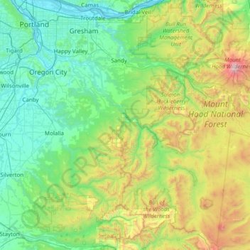
Nombre: Mapa topográfico Clackamas County, altitud, relieve.
Lugar: Clackamas County, Oregon, United States of America (44.88571 -122.86800 45.46167 -121.65099)
Altitud media: 660 m
Altitud mínima: 0 m
Altitud máxima: 3.392 m
Otros mapas topográficos
Haga clic en un mapa para ver su topografía, su altitud y su relieve.
Hillsboro
United States of America > Oregon > Hillsboro
Hillsboro, Washington County, Oregon, United States of America
Altitud media: 53 m
Tillamook County
United States of America > Oregon
Tillamook County, Oregon, United States of America
Altitud media: 236 m
Multnomah County
United States of America > Oregon
Multnomah County, Oregon, United States of America
Altitud media: 334 m
Coos County
United States of America > Oregon
Coos County, Oregon, United States of America
Altitud media: 266 m