
Mapa topográfico Cheyenne
Mapa interactivo
Haga clic en el mapa para ver la altitud.
Acerca de este mapa
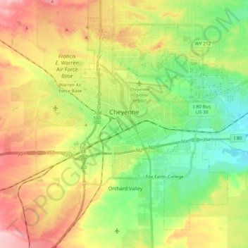
Nombre: Mapa topográfico Cheyenne, altitud, relieve.
Lugar: Cheyenne, Laramie County, Wyoming, United States (41.07310 -104.86112 41.19303 -104.67493)
Altitud media: 1.871 m
Altitud mínima: 1.803 m
Altitud máxima: 1.962 m
The Cheyenne Regional Airport was opened in 1920, initially serving as a stop for airmail. It soon developed into a civil-military airport, serving DC-3s and various military craft. During World War II, hundreds of B-17s, B-24s, and PBYs were outfitted and upgraded at the airfield. Today, it serves a number of military functions, and as a high-altitude testbed for civilian craft.[16]
Otros mapas topográficos
Haga clic en un mapa para ver su topografía, su altitud y su relieve.
Saddle Ridge Park
United States > Wyoming > Laramie County > Cheyenne
Saddle Ridge Park, Cheyenne, Laramie County, Wyoming, United States
Altitud media: 1.829 m
Cheyenne
United States > Wyoming > Laramie County > Cheyenne
Cheyenne, Laramie County, Wyoming, 82002, United States
Altitud media: 1.891 m
Ranchettes
United States > Wyoming > Laramie County > Cheyenne > Ranchettes
Ranchettes, Cheyenne, Laramie County, Wyoming, 82009, United States
Altitud media: 1.869 m