
Haz una donación
Mapa topográfico June Lake
Haga clic en el mapa para ver la altitud.
Haz una donación
June Lake
June Lake is an unincorporated community and census-designated place (CDP) in Mono County, California, United States. It is located against the southern rim of the Mono Basin, 12.5 miles (20 km) south of Lee Vining, at an elevation of 7,654 feet (2,333 m).
Haz una donación
Acerca de este mapa
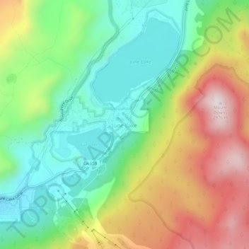
Nombre: Mapa topográfico June Lake, altitud, relieve.
Lugar: June Lake, Mono County, California, 93529, United States (37.75853 -119.09625 37.79853 -119.05625)
Altitud media: 2.548 m
Altitud mínima: 2.271 m
Altitud máxima: 2.973 m
Haz una donación
Otros mapas topográficos
Haga clic en un mapa para ver su topografía, su altitud y su relieve.
Mono Lake
United States > California > Mono County
Lake Russell was the prehistoric predecessor to Mono Lake, during the Pleistocene. Its shoreline reached the modern-day elevation of 7,480 feet (2,280 m), about 1,100 feet (330 m) higher than the present-day lake. As of 1.6 million years ago, Lake Russell discharged to the northeast, into the Walker River…
Altitud media: 2.008 m
Haz una donación
Haz una donación